

-
About
History and Culture
Introduction of the Upazila
Geographical and Economic
-
Upazila Parishod
Upazila Parishod Office
উপজেলা পরিষদের মাসিক সভা সংক্রান্ত
স্থায়ী কমিটির সভার রেজুলেশন
-
আইন-শৃঙ্খলা কমিটি
-
যোগাযোগ ও ভৌত অবকাঠামো উন্নয়ন কমিটি
-
কৃষি ও সেচ কমিটি
-
মাধ্যমিক ও মাদ্রাসা শিক্ষা কমিটি
-
প্রাথমিক ও গণশিক্ষা কমিটি
-
স্বাস্থ্য ও পরিবার পরিকল্পনা কমিটি
-
যুব ও ক্রীড়া উন্নয়ন কমিটি
-
মহিলা ও শিশু উন্নয়ন কমিটি
-
সমাজ কল্যাণ কমিটি
-
মুক্তিযোদ্ধা কমিটি
-
মৎস্য ও প্রাণিসম্পদ কমিটি
-
পল্লী উন্নয়ন ও সমবায় কমিটি
-
সাংস্কৃতিক বিষয়ক কমিটি
-
পরিবেশ ও বন উন্নয়ন কমিটি
-
অর্থ, বাজেট, পরিকল্পনা ও স্থানীয় সম্পদ আহরণ কমিটি
-
জনস্বাস্থ্য, স্যানিটেশন ও বিশুদ্ধ পানি সরবরাহ কমিটি
-
উপজেলা বাজার মূল্য পর্যবেক্ষণ, মনিটরিং ও নিয়ন্ত্রণ কমিটি
প্রকল্প সম্পর্কিত তথ্য
বার্ষিক উন্নয়ন পরিকল্পনা
পঞ্চবার্ষিক পরিকল্পনা
বাজেট
-
আইন-শৃঙ্খলা কমিটি
-
Administration
Upazila Nirbhai Officer
Essential Information
Service and Others
-
Govt. Offices
Law and order matters
Engineering and communication
Health related
Agriculture and food related issues
Education related
Land affairs
Others
-
Others Offices
Educational Institude
Private companies
Religious Institution
-
E-Services
National e-service
National e-service
-
Contacts
- Gallery
-
Corona Vaccine Registration
-
About
History and Culture
Introduction of the Upazila
Geographical and Economic
-
Upazila Parishod
Upazila Parishod Office
উপজেলা পরিষদের মাসিক সভা সংক্রান্ত
স্থায়ী কমিটির সভার রেজুলেশন
- আইন-শৃঙ্খলা কমিটি
- যোগাযোগ ও ভৌত অবকাঠামো উন্নয়ন কমিটি
- কৃষি ও সেচ কমিটি
- মাধ্যমিক ও মাদ্রাসা শিক্ষা কমিটি
- প্রাথমিক ও গণশিক্ষা কমিটি
- স্বাস্থ্য ও পরিবার পরিকল্পনা কমিটি
- যুব ও ক্রীড়া উন্নয়ন কমিটি
- মহিলা ও শিশু উন্নয়ন কমিটি
- সমাজ কল্যাণ কমিটি
- মুক্তিযোদ্ধা কমিটি
- মৎস্য ও প্রাণিসম্পদ কমিটি
- পল্লী উন্নয়ন ও সমবায় কমিটি
- সাংস্কৃতিক বিষয়ক কমিটি
- পরিবেশ ও বন উন্নয়ন কমিটি
- অর্থ, বাজেট, পরিকল্পনা ও স্থানীয় সম্পদ আহরণ কমিটি
- জনস্বাস্থ্য, স্যানিটেশন ও বিশুদ্ধ পানি সরবরাহ কমিটি
- উপজেলা বাজার মূল্য পর্যবেক্ষণ, মনিটরিং ও নিয়ন্ত্রণ কমিটি
প্রকল্প সম্পর্কিত তথ্য
বার্ষিক উন্নয়ন পরিকল্পনা
পঞ্চবার্ষিক পরিকল্পনা
বাজেট
-
Administration
Upazila Nirbhai Officer
Essential Information
Service and Others
-
Govt. Offices
Law and order matters
Engineering and communication
Health related
Agriculture and food related issues
Education related
Land affairs
Others
-
Others Offices
Educational Institude
Private companies
Religious Institution
-
E-Services
National e-service
National e-service
-
Contacts
-
Gallery
National Mourning Day 2020
-
Corona Vaccine Registration
Roangchhari upazila at a glance
Geographical Introduction Remote hilly natural forest area. Boundary- A. Rajsthali Upazila. South Ruma Upazila. East Bilaichhari Upazila. West Bandarban Sadar Upazila.
The background of the upazila is "Rakhing Chhara" where the Taracha canal merges. Before long, a settlement of Marma tribes was formed at the mouth of that Rakhing Chhara. As the town was built on the banks of the Rakhine Rhyme, the locals called the town Rakhine Wah, according to the custom of the Marma tribes. "Rakhing Wah" means the mouth of the Rakhine rhyme. Over time, Bengalis came here from the neighboring Chittagong district for trade and commerce. The market developed here on a small scale. Notably, the word "Rakhine or Rakhine" means the Arakan Province or Arakanese in the state of Burma or Myanmar. In the regional language of Chittagong, Arakan is called "Roang". That is why the local Bengalis called "Rakhing Wah" as "Roangchhari" and it became popular over time.
Roangchhari upazila covers an area of 443 sq km just east of Bandarban district headquarters. The total population of this upazila is 22,629 people ... The people of the hilly region belong to the Rgudra ethnic group. Most of them are zoom farmers. Although most of the land of the upazila is hilly, the area under cultivable land is about 3,963 hectares. It produces an average of 4,091 MT per year.
The area was established as an administrative thana on 25 October 1983 and was upgraded to an upazila on 15 March 1983.
Unions Unions: 04 (four) T.1) Roangchhari Sadar, 2) Taracha, 3) Alekshyang, 4) Noapatang
Tradition of the upazila All the small ethnic groups living in the Chittagong Hill Tracts live in this upazila. The unique way of life of each small ethnic group is a unique feature of these upazilas.
Language and culture 11 small ethnic groups including Bengalis live in this upazila. Each of which has a different culture and language.
List of Liberation War and Freedom Fighters There are no freedom fighters in this upazila.
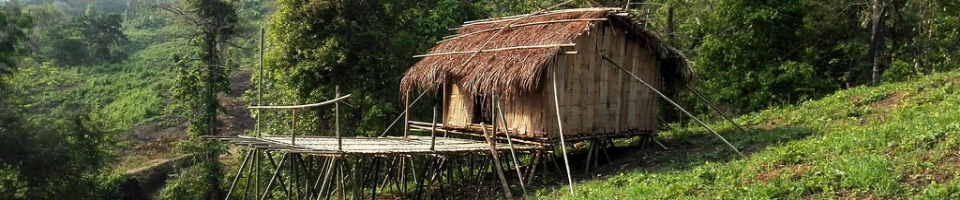
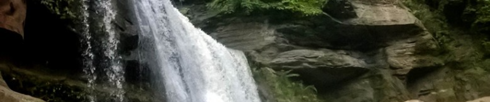
Places of interest Ramjadi Temple: This temple is located at Hada Babu Ghona, Roangchhari in Kalaghata of Bandarban district. At a distance of only 4 km, there are 2 large temples and 2 of them are in a deserted area just outside the city. If you have the habit of walking, you can walk away from the city. Devatakhum: Bandarban is the paradise of Khum. And there is a huge jungle hidden in this khumei and due to its steep hills the sunlight does not reach properly during the day and inside. The deeper you float the raft, the colder and quieter the environment will be. Next to Devtakhum there is a waterfall. There is a cloud on the way. If you want to go to Devatakhum, you have to go to Bandarban first. From Bandarban to Roangchhari. You have to make a strong bamboo valve. You have to cross the Pong Su Aung Khum first by going to Shilbandha. Devatakhum begins after crossing Pong Su Aung Khum. According to local tribes, Devatakhum is 50 feet deep and more than 600 feet long. Tinap Saitar: Tinap Saitar is the largest waterfall in Bangladesh in terms of water flow. It is located deep inside the Paindu canal. Jhiripath on the way to Tinap Saitar is very interesting. During the monsoon season, water flow increases in Tinap Saitar. Tinap Saitar is one of the tourist attractions of Bangladesh. You can reach Roangchhari by bus from Bandarban bus stand. The bus takes an hour. You have to go to Roangchhari, register at the police station and hire a guide. Tinap Saitar can be reached through Keplong Para, Paikhong Para, Ronin Para, Debachhara Para. Kachhapatli Shilbandha Jharna: This waterfall is well known as a very traditional place. After becoming known as Jharna, there is a daily flow of tourists and thirsty people from far and wide. Shilbandha Para can be seen as soon as you walk about 2 km of unpaved road from Kachchapatli Union, 10 km away from Roangchhari. Shilbandha Jharna is a 10 minute walk from this neighborhood. Sippy Hills: Sippy is a hill. Its height is 2939 feet. There are different names in different indigenous languages. Bam race is called Sippy, Tangchanga - Rametang, Marma - Ramatang, Pangkhoa - Arsuang which means rooster crest. Also called by many names including Ramjum. Sippy is the southernmost peak (left) of the three peaks that can be seen from Sippy Para. The middle one is Arsuang. The right one has no name. Some also call the survival of the South Sippy Arsuang. It will take about 3 hours to reach Paikshang Para from Roangchhari. It will take about 2.40 hours from Paikshang Para to Ronin Para. It will take about 4 hours to reach Sippy Chura from Roninpara. Ronin Para: Roninpara is located in a very remote area but it is as beautiful as the picture. All the houses are located on poles a few feet high. Several houses have electricity for the benefit of solar panels. There is no water problem here. The water is supplied to the whole village through iron pipes from the ponds that come down from Sippy's body. It will take about 3 hours to reach Paikhyang Para from Roangchhari. It will take about 2.40 hours from Paikshang Para to Ronin Para.
Eminent personalities do not have significant eminent personalities.
Sports and recreation Football is the main sport here. Each small ethnic group has its own songs and dances. Which are served at their various festivals.
Natural resources There are no mineral resources in this upazila. However, this upazila is rich in forest and fruit resources
No.


Planning and Implementation: Cabinet Division, A2I, BCC, DoICT and BASIS
Technical Assistance:
![]()
Developed By:
